pacman::p_load(maptools, sf, raster, spatstat, tmap, tidyverse)Hands-on Exercise - 1st Order Spatial Point Patterns Analysis
Session 4
1 Getting Started
1.1 Installing and Loading R packages
2 Spatial Data Wrangling
2.1 Importing the spatial data
childcare_sf <- st_read("data/child-care-services-geojson.geojson") %>%
  st_transform(crs = 3414)
Reading layer `child-care-services-geojson' from data source
`C:\p-haas\IS415\Hands-on_Ex\Hands-on_Ex04\data\child-care-services-geojson.geojson'
using driver `GeoJSON'
Simple feature collection with 1545 features and 2 fields
Geometry type: POINT
Dimension: XYZ
Bounding box: xmin: 103.6824 ymin: 1.248403 xmax: 103.9897 ymax: 1.462134
z_range: zmin: 0 zmax: 0
Geodetic CRS: WGS 84sg_sf <- st_read(dsn = "data", layer="CostalOutline")Reading layer `CostalOutline' from data source
`C:\p-haas\IS415\Hands-on_Ex\Hands-on_Ex04\data' using driver `ESRI Shapefile'
Simple feature collection with 60 features and 4 fields
Geometry type: POLYGON
Dimension: XY
Bounding box: xmin: 2663.926 ymin: 16357.98 xmax: 56047.79 ymax: 50244.03
Projected CRS: SVY21mpsz_sf <- st_read(dsn = "data",
layer = "MP14_SUBZONE_WEB_PL")Reading layer `MP14_SUBZONE_WEB_PL' from data source
`C:\p-haas\IS415\Hands-on_Ex\Hands-on_Ex04\data' using driver `ESRI Shapefile'
Simple feature collection with 323 features and 15 fields
Geometry type: MULTIPOLYGON
Dimension: XY
Bounding box: xmin: 2667.538 ymin: 15748.72 xmax: 56396.44 ymax: 50256.33
Projected CRS: SVY212.1.1 DIY
st_crs(sg_sf)Coordinate Reference System:
User input: SVY21
wkt:
PROJCRS["SVY21",
BASEGEOGCRS["SVY21[WGS84]",
DATUM["World Geodetic System 1984",
ELLIPSOID["WGS 84",6378137,298.257223563,
LENGTHUNIT["metre",1]],
ID["EPSG",6326]],
PRIMEM["Greenwich",0,
ANGLEUNIT["Degree",0.0174532925199433]]],
CONVERSION["unnamed",
METHOD["Transverse Mercator",
ID["EPSG",9807]],
PARAMETER["Latitude of natural origin",1.36666666666667,
ANGLEUNIT["Degree",0.0174532925199433],
ID["EPSG",8801]],
PARAMETER["Longitude of natural origin",103.833333333333,
ANGLEUNIT["Degree",0.0174532925199433],
ID["EPSG",8802]],
PARAMETER["Scale factor at natural origin",1,
SCALEUNIT["unity",1],
ID["EPSG",8805]],
PARAMETER["False easting",28001.642,
LENGTHUNIT["metre",1],
ID["EPSG",8806]],
PARAMETER["False northing",38744.572,
LENGTHUNIT["metre",1],
ID["EPSG",8807]]],
CS[Cartesian,2],
AXIS["(E)",east,
ORDER[1],
LENGTHUNIT["metre",1,
ID["EPSG",9001]]],
AXIS["(N)",north,
ORDER[2],
LENGTHUNIT["metre",1,
ID["EPSG",9001]]]]st_crs(mpsz_sf)Coordinate Reference System:
User input: SVY21
wkt:
PROJCRS["SVY21",
BASEGEOGCRS["SVY21[WGS84]",
DATUM["World Geodetic System 1984",
ELLIPSOID["WGS 84",6378137,298.257223563,
LENGTHUNIT["metre",1]],
ID["EPSG",6326]],
PRIMEM["Greenwich",0,
ANGLEUNIT["Degree",0.0174532925199433]]],
CONVERSION["unnamed",
METHOD["Transverse Mercator",
ID["EPSG",9807]],
PARAMETER["Latitude of natural origin",1.36666666666667,
ANGLEUNIT["Degree",0.0174532925199433],
ID["EPSG",8801]],
PARAMETER["Longitude of natural origin",103.833333333333,
ANGLEUNIT["Degree",0.0174532925199433],
ID["EPSG",8802]],
PARAMETER["Scale factor at natural origin",1,
SCALEUNIT["unity",1],
ID["EPSG",8805]],
PARAMETER["False easting",28001.642,
LENGTHUNIT["metre",1],
ID["EPSG",8806]],
PARAMETER["False northing",38744.572,
LENGTHUNIT["metre",1],
ID["EPSG",8807]]],
CS[Cartesian,2],
AXIS["(E)",east,
ORDER[1],
LENGTHUNIT["metre",1,
ID["EPSG",9001]]],
AXIS["(N)",north,
ORDER[2],
LENGTHUNIT["metre",1,
ID["EPSG",9001]]]]sg_sf = sg_sf %>%
st_set_crs(3414)
mpsz_sf = mpsz_sf %>%
st_set_crs(3414)mpsz_sfSimple feature collection with 323 features and 15 fields
Geometry type: MULTIPOLYGON
Dimension: XY
Bounding box: xmin: 2667.538 ymin: 15748.72 xmax: 56396.44 ymax: 50256.33
Projected CRS: SVY21 / Singapore TM
First 10 features:
OBJECTID SUBZONE_NO SUBZONE_N SUBZONE_C CA_IND PLN_AREA_N
1 1 1 MARINA SOUTH MSSZ01 Y MARINA SOUTH
2 2 1 PEARL'S HILL OTSZ01 Y OUTRAM
3 3 3 BOAT QUAY SRSZ03 Y SINGAPORE RIVER
4 4 8 HENDERSON HILL BMSZ08 N BUKIT MERAH
5 5 3 REDHILL BMSZ03 N BUKIT MERAH
6 6 7 ALEXANDRA HILL BMSZ07 N BUKIT MERAH
7 7 9 BUKIT HO SWEE BMSZ09 N BUKIT MERAH
8 8 2 CLARKE QUAY SRSZ02 Y SINGAPORE RIVER
9 9 13 PASIR PANJANG 1 QTSZ13 N QUEENSTOWN
10 10 7 QUEENSWAY QTSZ07 N QUEENSTOWN
PLN_AREA_C REGION_N REGION_C INC_CRC FMEL_UPD_D X_ADDR
1 MS CENTRAL REGION CR 5ED7EB253F99252E 2014-12-05 31595.84
2 OT CENTRAL REGION CR 8C7149B9EB32EEFC 2014-12-05 28679.06
3 SR CENTRAL REGION CR C35FEFF02B13E0E5 2014-12-05 29654.96
4 BM CENTRAL REGION CR 3775D82C5DDBEFBD 2014-12-05 26782.83
5 BM CENTRAL REGION CR 85D9ABEF0A40678F 2014-12-05 26201.96
6 BM CENTRAL REGION CR 9D286521EF5E3B59 2014-12-05 25358.82
7 BM CENTRAL REGION CR 7839A8577144EFE2 2014-12-05 27680.06
8 SR CENTRAL REGION CR 48661DC0FBA09F7A 2014-12-05 29253.21
9 QT CENTRAL REGION CR 1F721290C421BFAB 2014-12-05 22077.34
10 QT CENTRAL REGION CR 3580D2AFFBEE914C 2014-12-05 24168.31
Y_ADDR SHAPE_Leng SHAPE_Area geometry
1 29220.19 5267.381 1630379.3 MULTIPOLYGON (((31495.56 30...
2 29782.05 3506.107 559816.2 MULTIPOLYGON (((29092.28 30...
3 29974.66 1740.926 160807.5 MULTIPOLYGON (((29932.33 29...
4 29933.77 3313.625 595428.9 MULTIPOLYGON (((27131.28 30...
5 30005.70 2825.594 387429.4 MULTIPOLYGON (((26451.03 30...
6 29991.38 4428.913 1030378.8 MULTIPOLYGON (((25899.7 297...
7 30230.86 3275.312 551732.0 MULTIPOLYGON (((27746.95 30...
8 30222.86 2208.619 290184.7 MULTIPOLYGON (((29351.26 29...
9 29893.78 6571.323 1084792.3 MULTIPOLYGON (((20996.49 30...
10 30104.18 3454.239 631644.3 MULTIPOLYGON (((24472.11 29...2.2 Mapping the geospatial data sets
tmap_mode('plot')
tm_shape(mpsz_sf)+
  tm_borders()+
  tm_fill()+
  tm_shape(childcare_sf)+
  tm_dots()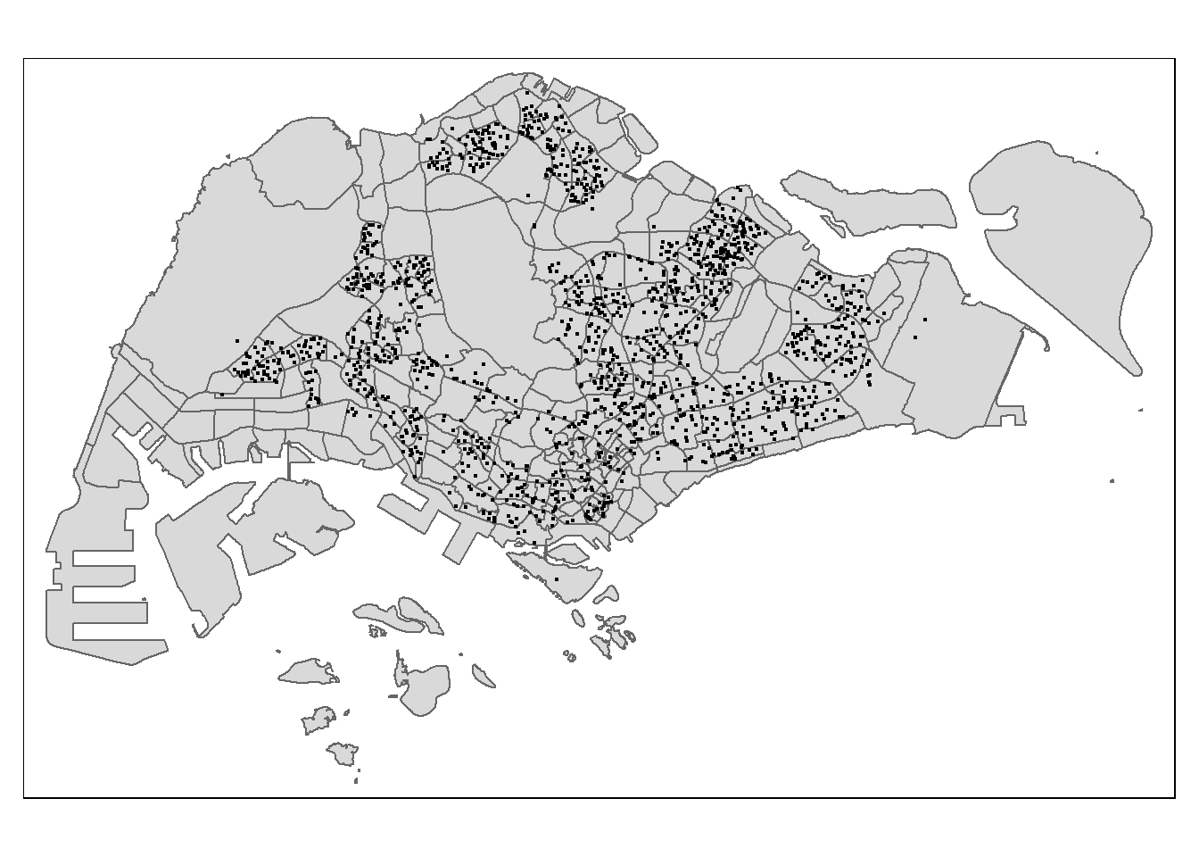
tmap_mode('view')
tm_shape(childcare_sf)+
tm_dots()tmap_mode('plot')3 Geospatial Data Wrangling
3.1 Converting sf data frames to sp’s Spatial* class
childcare <- as_Spatial(childcare_sf)
mpsz <- as_Spatial(mpsz_sf)
sg <- as_Spatial(sg_sf)childcareclass : SpatialPointsDataFrame
features : 1545
extent : 11203.01, 45404.24, 25667.6, 49300.88 (xmin, xmax, ymin, ymax)
crs : +proj=tmerc +lat_0=1.36666666666667 +lon_0=103.833333333333 +k=1 +x_0=28001.642 +y_0=38744.572 +ellps=WGS84 +towgs84=0,0,0,0,0,0,0 +units=m +no_defs
variables : 2
names : Name, Description
min values : kml_1, <center><table><tr><th colspan='2' align='center'><em>Attributes</em></th></tr><tr bgcolor="#E3E3F3"> <th>ADDRESSBLOCKHOUSENUMBER</th> <td></td> </tr><tr bgcolor=""> <th>ADDRESSBUILDINGNAME</th> <td></td> </tr><tr bgcolor="#E3E3F3"> <th>ADDRESSPOSTALCODE</th> <td>018989</td> </tr><tr bgcolor=""> <th>ADDRESSSTREETNAME</th> <td>1, MARINA BOULEVARD, #B1 - 01, ONE MARINA BOULEVARD, SINGAPORE 018989</td> </tr><tr bgcolor="#E3E3F3"> <th>ADDRESSTYPE</th> <td></td> </tr><tr bgcolor=""> <th>DESCRIPTION</th> <td></td> </tr><tr bgcolor="#E3E3F3"> <th>HYPERLINK</th> <td></td> </tr><tr bgcolor=""> <th>LANDXADDRESSPOINT</th> <td>0</td> </tr><tr bgcolor="#E3E3F3"> <th>LANDYADDRESSPOINT</th> <td>0</td> </tr><tr bgcolor=""> <th>NAME</th> <td>THE LITTLE SKOOL-HOUSE INTERNATIONAL PTE. LTD.</td> </tr><tr bgcolor="#E3E3F3"> <th>PHOTOURL</th> <td></td> </tr><tr bgcolor=""> <th>ADDRESSFLOORNUMBER</th> <td></td> </tr><tr bgcolor="#E3E3F3"> <th>INC_CRC</th> <td>08F73931F4A691F4</td> </tr><tr bgcolor=""> <th>FMEL_UPD_D</th> <td>20200826094036</td> </tr><tr bgcolor="#E3E3F3"> <th>ADDRESSUNITNUMBER</th> <td></td> </tr></table></center>
max values : kml_999, <center><table><tr><th colspan='2' align='center'><em>Attributes</em></th></tr><tr bgcolor="#E3E3F3"> <th>ADDRESSBLOCKHOUSENUMBER</th> <td></td> </tr><tr bgcolor=""> <th>ADDRESSBUILDINGNAME</th> <td></td> </tr><tr bgcolor="#E3E3F3"> <th>ADDRESSPOSTALCODE</th> <td>829646</td> </tr><tr bgcolor=""> <th>ADDRESSSTREETNAME</th> <td>200, PONGGOL SEVENTEENTH AVENUE, SINGAPORE 829646</td> </tr><tr bgcolor="#E3E3F3"> <th>ADDRESSTYPE</th> <td></td> </tr><tr bgcolor=""> <th>DESCRIPTION</th> <td>Child Care Services</td> </tr><tr bgcolor="#E3E3F3"> <th>HYPERLINK</th> <td></td> </tr><tr bgcolor=""> <th>LANDXADDRESSPOINT</th> <td>0</td> </tr><tr bgcolor="#E3E3F3"> <th>LANDYADDRESSPOINT</th> <td>0</td> </tr><tr bgcolor=""> <th>NAME</th> <td>RAFFLES KIDZ @ PUNGGOL PTE LTD</td> </tr><tr bgcolor="#E3E3F3"> <th>PHOTOURL</th> <td></td> </tr><tr bgcolor=""> <th>ADDRESSFLOORNUMBER</th> <td></td> </tr><tr bgcolor="#E3E3F3"> <th>INC_CRC</th> <td>379D017BF244B0FA</td> </tr><tr bgcolor=""> <th>FMEL_UPD_D</th> <td>20200826094036</td> </tr><tr bgcolor="#E3E3F3"> <th>ADDRESSUNITNUMBER</th> <td></td> </tr></table></center> mpszclass : SpatialPolygonsDataFrame
features : 323
extent : 2667.538, 56396.44, 15748.72, 50256.33 (xmin, xmax, ymin, ymax)
crs : +proj=tmerc +lat_0=1.36666666666667 +lon_0=103.833333333333 +k=1 +x_0=28001.642 +y_0=38744.572 +ellps=WGS84 +towgs84=0,0,0,0,0,0,0 +units=m +no_defs
variables : 15
names : OBJECTID, SUBZONE_NO, SUBZONE_N, SUBZONE_C, CA_IND, PLN_AREA_N, PLN_AREA_C, REGION_N, REGION_C, INC_CRC, FMEL_UPD_D, X_ADDR, Y_ADDR, SHAPE_Leng, SHAPE_Area
min values : 1, 1, ADMIRALTY, AMSZ01, N, ANG MO KIO, AM, CENTRAL REGION, CR, 00F5E30B5C9B7AD8, 16409, 5092.8949, 19579.069, 871.554887798, 39437.9352703
max values : 323, 17, YUNNAN, YSSZ09, Y, YISHUN, YS, WEST REGION, WR, FFCCF172717C2EAF, 16409, 50424.7923, 49552.7904, 68083.9364708, 69748298.792 sgclass : SpatialPolygonsDataFrame
features : 60
extent : 2663.926, 56047.79, 16357.98, 50244.03 (xmin, xmax, ymin, ymax)
crs : +proj=tmerc +lat_0=1.36666666666667 +lon_0=103.833333333333 +k=1 +x_0=28001.642 +y_0=38744.572 +ellps=WGS84 +towgs84=0,0,0,0,0,0,0 +units=m +no_defs
variables : 4
names : GDO_GID, MSLINK, MAPID, COSTAL_NAM
min values : 1, 1, 0, ISLAND LINK
max values : 60, 67, 0, SINGAPORE - MAIN ISLAND 3.2 Converting the Spatial* class into generic sp format
childcare_sp <- as(childcare, "SpatialPoints")
sg_sp <- as(sg, "SpatialPolygons")childcare_spclass : SpatialPoints
features : 1545
extent : 11203.01, 45404.24, 25667.6, 49300.88 (xmin, xmax, ymin, ymax)
crs : +proj=tmerc +lat_0=1.36666666666667 +lon_0=103.833333333333 +k=1 +x_0=28001.642 +y_0=38744.572 +ellps=WGS84 +towgs84=0,0,0,0,0,0,0 +units=m +no_defs 3.3 Converting the generic sp format into spatstat’s ppp format
childcare_ppp <- as(childcare_sp, "ppp")
childcare_ppp
Planar point pattern: 1545 points
window: rectangle = [11203.01, 45404.24] x [25667.6, 49300.88] unitsplot(childcare_ppp)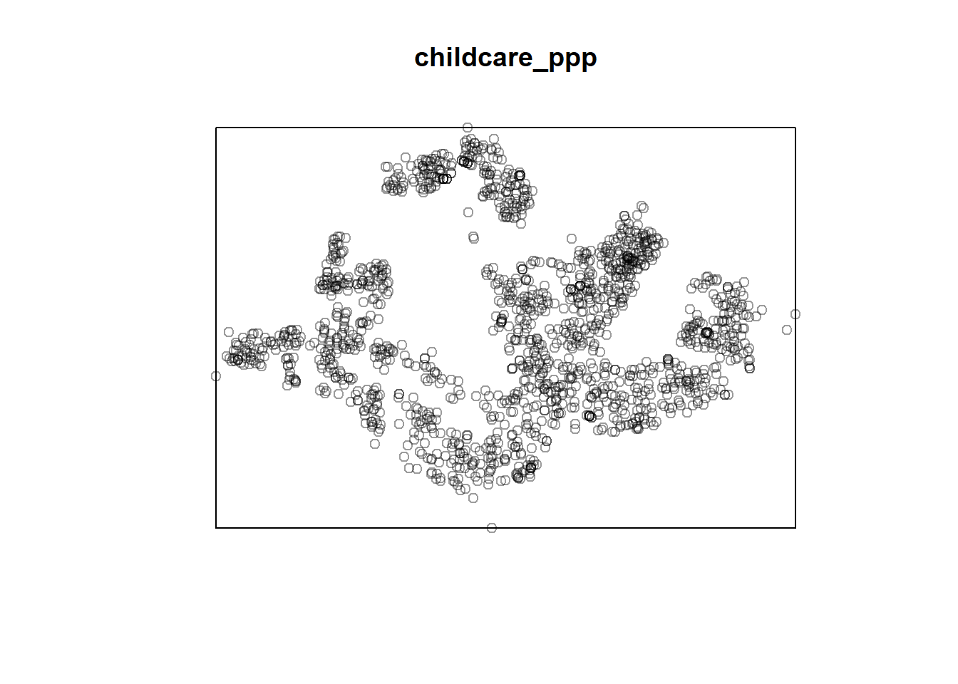
summary(childcare_ppp)Planar point pattern: 1545 points
Average intensity 1.91145e-06 points per square unit
*Pattern contains duplicated points*
Coordinates are given to 3 decimal places
i.e. rounded to the nearest multiple of 0.001 units
Window: rectangle = [11203.01, 45404.24] x [25667.6, 49300.88] units
(34200 x 23630 units)
Window area = 808287000 square units3.4 Handling duplicated points
any(duplicated(childcare_ppp))[1] TRUEsum(multiplicity(childcare_ppp) > 1)[1] 128childcare_ppp_jit <- rjitter(childcare_ppp,
retry=TRUE,
nsim=1,
drop=TRUE)any(duplicated(childcare_ppp_jit))[1] FALSE3.5 Creating owin object
sg_owin = as(sg_sp, "owin")plot(sg_owin)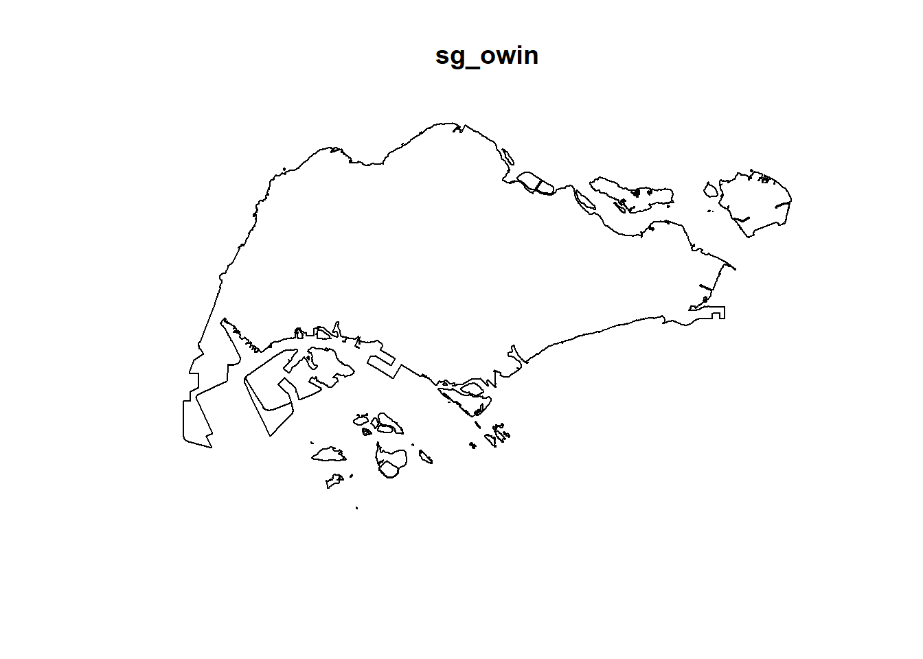
summary(sg_owin)Window: polygonal boundary
60 separate polygons (no holes)
vertices area relative.area
polygon 1 38 1.56140e+04 2.09e-05
polygon 2 735 4.69093e+06 6.27e-03
polygon 3 49 1.66986e+04 2.23e-05
polygon 4 76 3.12332e+05 4.17e-04
polygon 5 5141 6.36179e+08 8.50e-01
polygon 6 42 5.58317e+04 7.46e-05
polygon 7 67 1.31354e+06 1.75e-03
polygon 8 15 4.46420e+03 5.96e-06
polygon 9 14 5.46674e+03 7.30e-06
polygon 10 37 5.26194e+03 7.03e-06
polygon 11 53 3.44003e+04 4.59e-05
polygon 12 74 5.82234e+04 7.78e-05
polygon 13 69 5.63134e+04 7.52e-05
polygon 14 143 1.45139e+05 1.94e-04
polygon 15 165 3.38736e+05 4.52e-04
polygon 16 130 9.40465e+04 1.26e-04
polygon 17 19 1.80977e+03 2.42e-06
polygon 18 16 2.01046e+03 2.69e-06
polygon 19 93 4.30642e+05 5.75e-04
polygon 20 90 4.15092e+05 5.54e-04
polygon 21 721 1.92795e+06 2.57e-03
polygon 22 330 1.11896e+06 1.49e-03
polygon 23 115 9.28394e+05 1.24e-03
polygon 24 37 1.01705e+04 1.36e-05
polygon 25 25 1.66227e+04 2.22e-05
polygon 26 10 2.14507e+03 2.86e-06
polygon 27 190 2.02489e+05 2.70e-04
polygon 28 175 9.25904e+05 1.24e-03
polygon 29 1993 9.99217e+06 1.33e-02
polygon 30 38 2.42492e+04 3.24e-05
polygon 31 24 6.35239e+03 8.48e-06
polygon 32 53 6.35791e+05 8.49e-04
polygon 33 41 1.60161e+04 2.14e-05
polygon 34 22 2.54368e+03 3.40e-06
polygon 35 30 1.08382e+04 1.45e-05
polygon 36 327 2.16921e+06 2.90e-03
polygon 37 111 6.62927e+05 8.85e-04
polygon 38 90 1.15991e+05 1.55e-04
polygon 39 98 6.26829e+04 8.37e-05
polygon 40 415 3.25384e+06 4.35e-03
polygon 41 222 1.51142e+06 2.02e-03
polygon 42 107 6.33039e+05 8.45e-04
polygon 43 7 2.48299e+03 3.32e-06
polygon 44 17 3.28303e+04 4.38e-05
polygon 45 26 8.34758e+03 1.11e-05
polygon 46 177 4.67446e+05 6.24e-04
polygon 47 16 3.19460e+03 4.27e-06
polygon 48 15 4.87296e+03 6.51e-06
polygon 49 66 1.61841e+04 2.16e-05
polygon 50 149 5.63430e+06 7.53e-03
polygon 51 609 2.62570e+07 3.51e-02
polygon 52 8 7.82256e+03 1.04e-05
polygon 53 976 2.33447e+07 3.12e-02
polygon 54 55 8.25379e+04 1.10e-04
polygon 55 976 2.33447e+07 3.12e-02
polygon 56 61 3.33449e+05 4.45e-04
polygon 57 6 1.68410e+04 2.25e-05
polygon 58 4 9.45963e+03 1.26e-05
polygon 59 46 6.99702e+05 9.35e-04
polygon 60 13 7.00873e+04 9.36e-05
enclosing rectangle: [2663.93, 56047.79] x [16357.98, 50244.03] units
(53380 x 33890 units)
Window area = 748741000 square units
Fraction of frame area: 0.4143.6 Combining point events object and owin object
childcareSG_ppp = childcare_ppp[sg_owin]summary(childcareSG_ppp)Planar point pattern: 1545 points
Average intensity 2.063463e-06 points per square unit
*Pattern contains duplicated points*
Coordinates are given to 3 decimal places
i.e. rounded to the nearest multiple of 0.001 units
Window: polygonal boundary
60 separate polygons (no holes)
            vertices        area relative.area
polygon 1         38 1.56140e+04      2.09e-05
polygon 2        735 4.69093e+06      6.27e-03
polygon 3         49 1.66986e+04      2.23e-05
polygon 4         76 3.12332e+05      4.17e-04
polygon 5       5141 6.36179e+08      8.50e-01
polygon 6         42 5.58317e+04      7.46e-05
polygon 7         67 1.31354e+06      1.75e-03
polygon 8         15 4.46420e+03      5.96e-06
polygon 9         14 5.46674e+03      7.30e-06
polygon 10        37 5.26194e+03      7.03e-06
polygon 11        53 3.44003e+04      4.59e-05
polygon 12        74 5.82234e+04      7.78e-05
polygon 13        69 5.63134e+04      7.52e-05
polygon 14       143 1.45139e+05      1.94e-04
polygon 15       165 3.38736e+05      4.52e-04
polygon 16       130 9.40465e+04      1.26e-04
polygon 17        19 1.80977e+03      2.42e-06
polygon 18        16 2.01046e+03      2.69e-06
polygon 19        93 4.30642e+05      5.75e-04
polygon 20        90 4.15092e+05      5.54e-04
polygon 21       721 1.92795e+06      2.57e-03
polygon 22       330 1.11896e+06      1.49e-03
polygon 23       115 9.28394e+05      1.24e-03
polygon 24        37 1.01705e+04      1.36e-05
polygon 25        25 1.66227e+04      2.22e-05
polygon 26        10 2.14507e+03      2.86e-06
polygon 27       190 2.02489e+05      2.70e-04
polygon 28       175 9.25904e+05      1.24e-03
polygon 29      1993 9.99217e+06      1.33e-02
polygon 30        38 2.42492e+04      3.24e-05
polygon 31        24 6.35239e+03      8.48e-06
polygon 32        53 6.35791e+05      8.49e-04
polygon 33        41 1.60161e+04      2.14e-05
polygon 34        22 2.54368e+03      3.40e-06
polygon 35        30 1.08382e+04      1.45e-05
polygon 36       327 2.16921e+06      2.90e-03
polygon 37       111 6.62927e+05      8.85e-04
polygon 38        90 1.15991e+05      1.55e-04
polygon 39        98 6.26829e+04      8.37e-05
polygon 40       415 3.25384e+06      4.35e-03
polygon 41       222 1.51142e+06      2.02e-03
polygon 42       107 6.33039e+05      8.45e-04
polygon 43         7 2.48299e+03      3.32e-06
polygon 44        17 3.28303e+04      4.38e-05
polygon 45        26 8.34758e+03      1.11e-05
polygon 46       177 4.67446e+05      6.24e-04
polygon 47        16 3.19460e+03      4.27e-06
polygon 48        15 4.87296e+03      6.51e-06
polygon 49        66 1.61841e+04      2.16e-05
polygon 50       149 5.63430e+06      7.53e-03
polygon 51       609 2.62570e+07      3.51e-02
polygon 52         8 7.82256e+03      1.04e-05
polygon 53       976 2.33447e+07      3.12e-02
polygon 54        55 8.25379e+04      1.10e-04
polygon 55       976 2.33447e+07      3.12e-02
polygon 56        61 3.33449e+05      4.45e-04
polygon 57         6 1.68410e+04      2.25e-05
polygon 58         4 9.45963e+03      1.26e-05
polygon 59        46 6.99702e+05      9.35e-04
polygon 60        13 7.00873e+04      9.36e-05
enclosing rectangle: [2663.93, 56047.79] x [16357.98, 50244.03] units
                     (53380 x 33890 units)
Window area = 748741000 square units
Fraction of frame area: 0.414plot(childcareSG_ppp)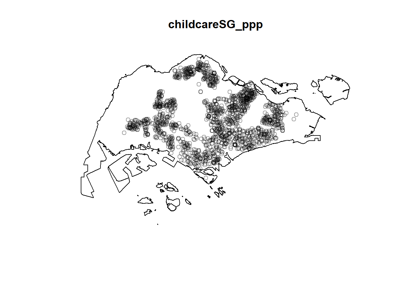
4 First-order Spatial Point Patterns Analysis
4.1 Kernel Density Estimation
4.1.1 Computing kernel density estimation using automatic bandwidth selection method
kde_childcareSG_bw <- density(childcareSG_ppp,
                              sigma=bw.diggle,
                              edge=TRUE,
                            kernel="gaussian")
plot(kde_childcareSG_bw)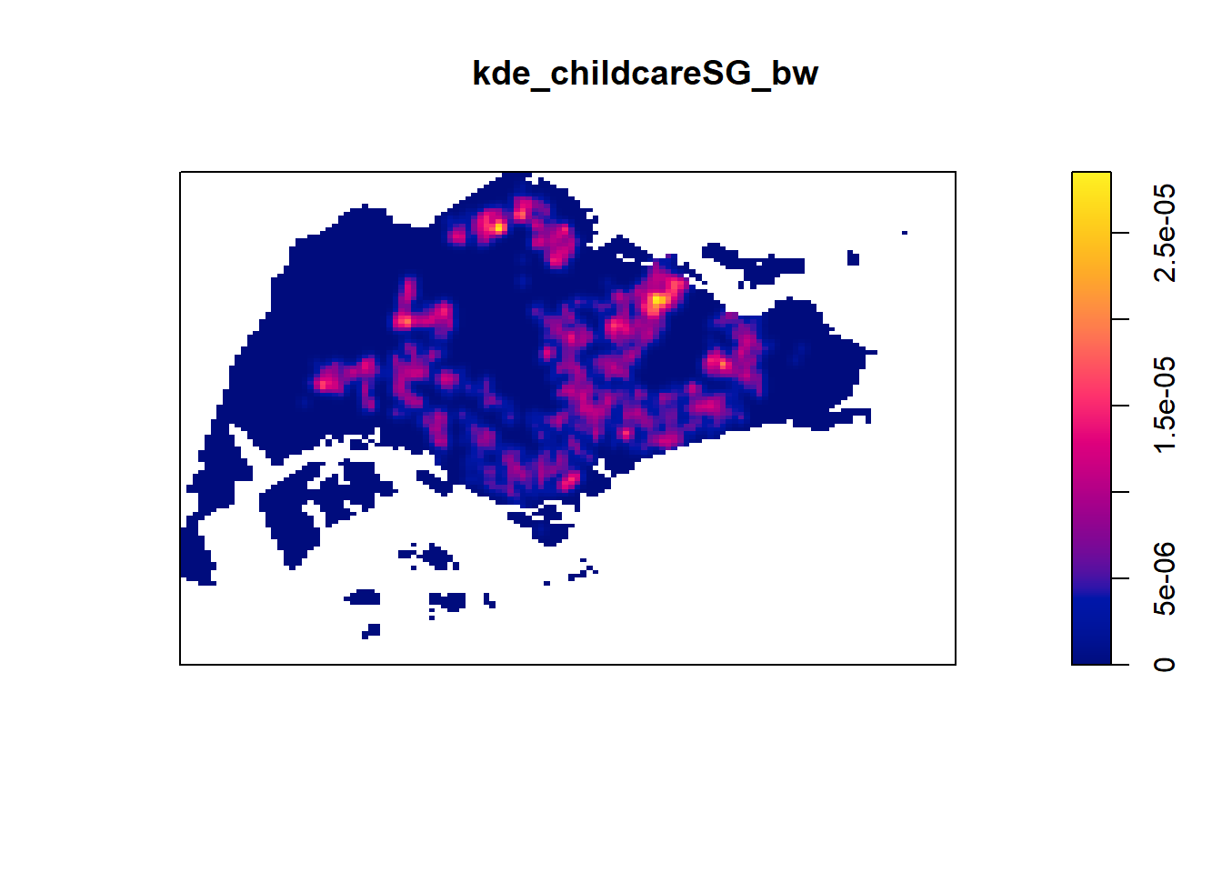
4.1.2 Rescalling KDE values
childcareSG_ppp.km <- rescale(childcareSG_ppp, 1000, "km")kde_childcareSG.bw <- density(childcareSG_ppp.km,
sigma=bw.diggle,
edge=TRUE,
kernel="gaussian")
plot(kde_childcareSG.bw)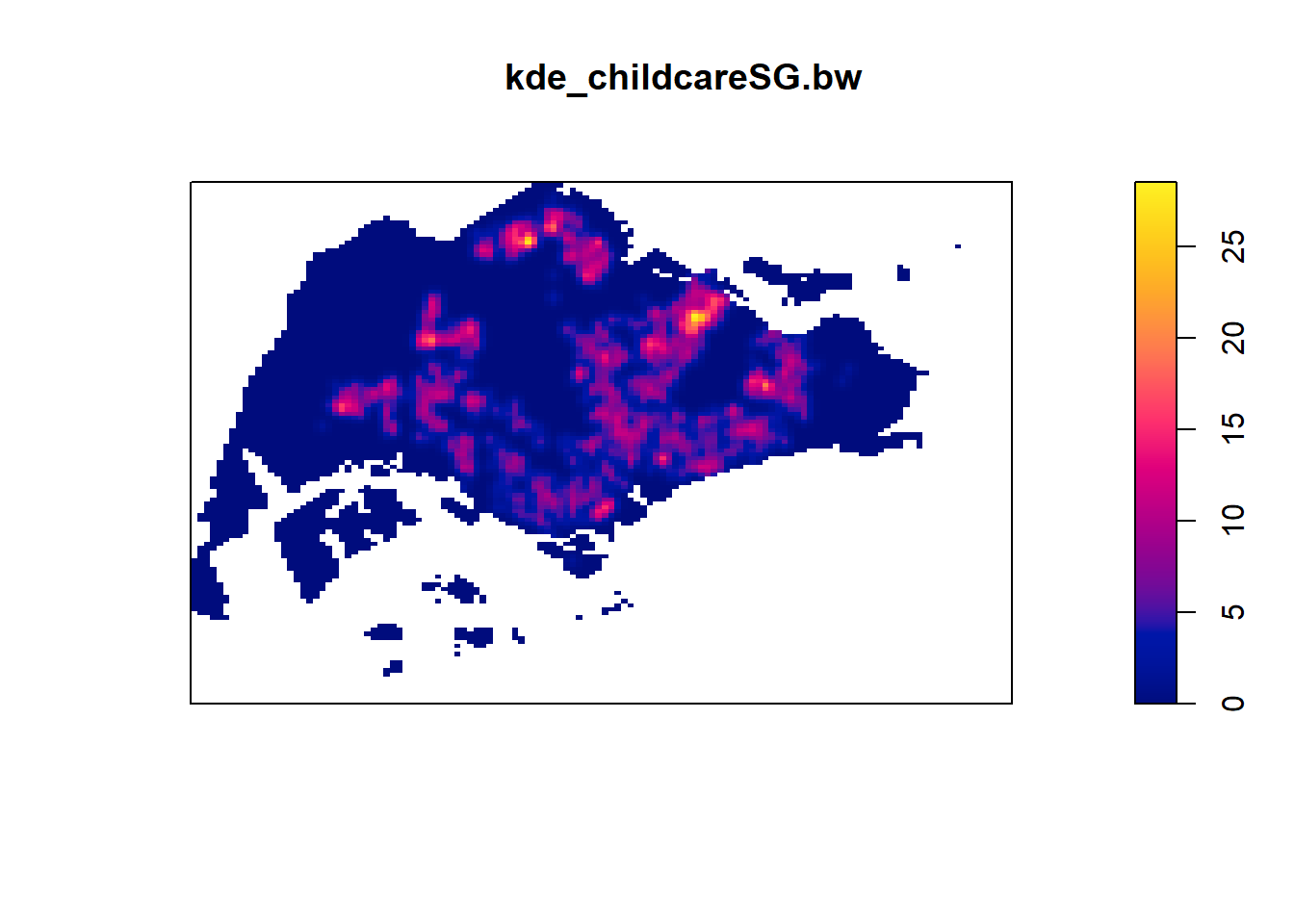
4.2 Working with different automatic bandwidth methods
bw.CvL(childcareSG_ppp.km); sigma
4.543278 bw.scott(childcareSG_ppp.km); sigma.x sigma.y
2.224898 1.450966 bw.ppl(childcareSG_ppp.km); sigma
0.3897114 bw.diggle(childcareSG_ppp.km) sigma
0.2984095 kde_childcareSG.ppl <- density(childcareSG_ppp.km,
sigma=bw.ppl,
edge=TRUE,
kernel="gaussian")
par(mfrow=c(1,2))
plot(kde_childcareSG.bw, main = "bw.diggle")
plot(kde_childcareSG.ppl, main = "bw.ppl")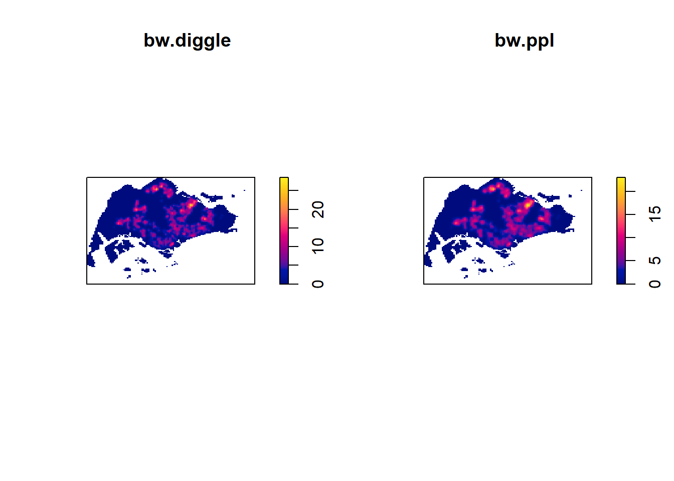
4.3 Working with different kernel methods
par(mfrow=c(2,2))
plot(density(childcareSG_ppp.km,
             sigma=bw.ppl,
             edge=TRUE,
             kernel="gaussian"),
     main="Gaussian")
plot(density(childcareSG_ppp.km,
             sigma=bw.ppl,
             edge=TRUE,
             kernel="epanechnikov"),
     main="Epanechnikov")
plot(density(childcareSG_ppp.km,
             sigma=bw.ppl,
             edge=TRUE,
             kernel="quartic"),
     main="Quartic")
plot(density(childcareSG_ppp.km,
             sigma=bw.ppl,
             edge=TRUE,
             kernel="disc"),
     main="Disc")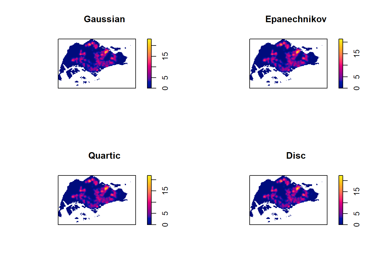
5 Fixed and Adaptive KDE
5.1 Computing KDE by using fixed bandwidth
kde_childcareSG_600 <- density(childcareSG_ppp.km,
                               sigma=0.6,
                               edge=TRUE,
                               kernel="gaussian")
plot(kde_childcareSG_600)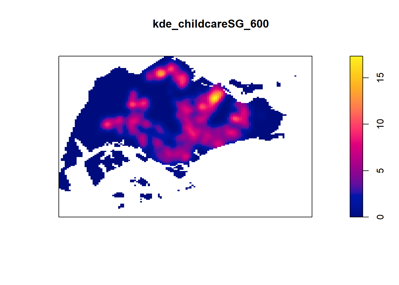
5.2 Computing KDE by using adaptive bandwidth
kde_childcareSG_adaptive <- adaptive.density(childcareSG_ppp.km,
                                             method="kernel")
plot(kde_childcareSG_adaptive)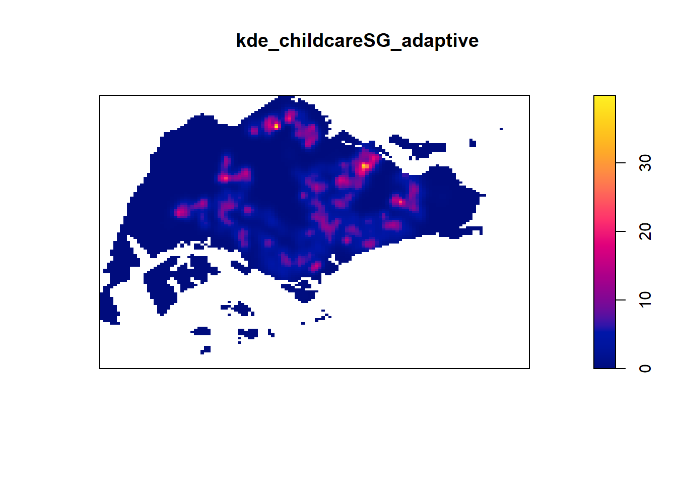
par(mfrow=c(1,2))
plot(kde_childcareSG.bw, main = "Fixed bandwidth")
plot(kde_childcareSG_adaptive, main = "Adaptive bandwidth")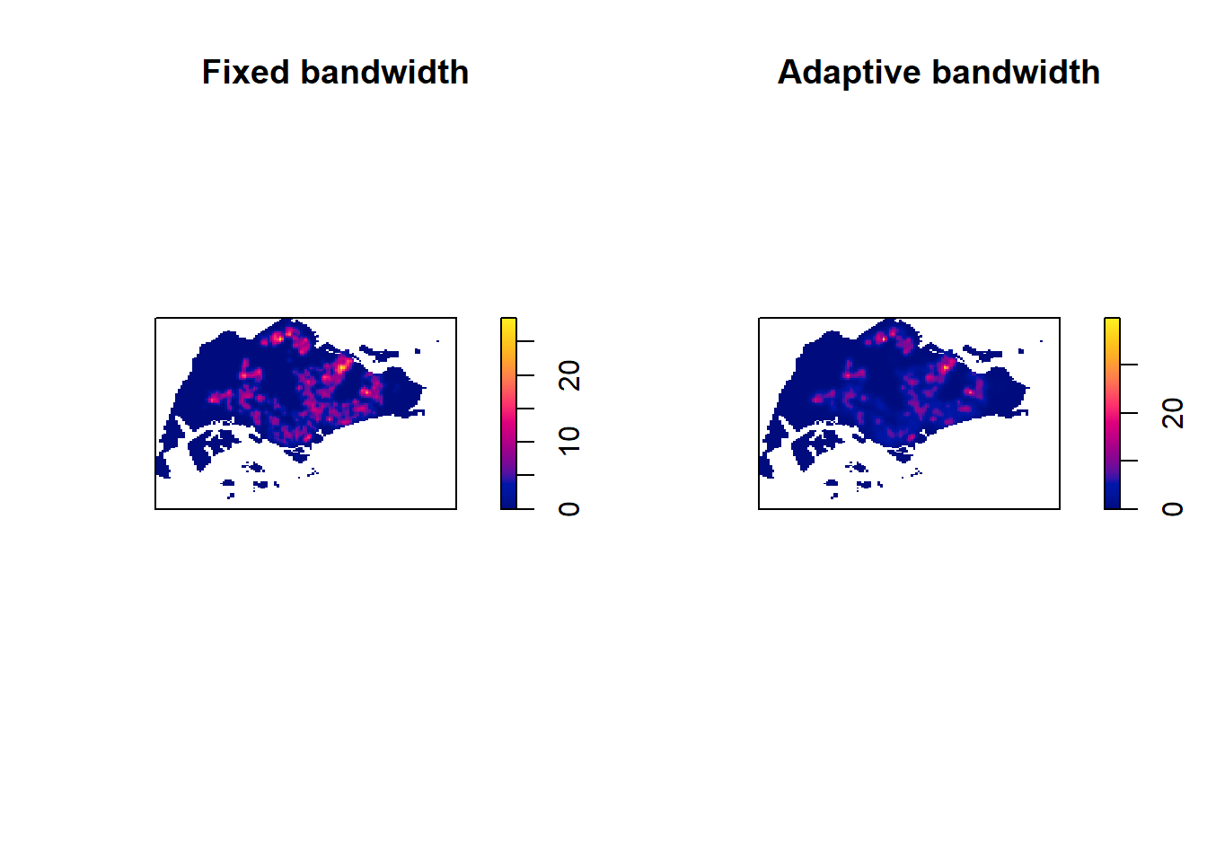
5.3 Converting KDE into grid object
gridded_kde_childcareSG_bw <- as.SpatialGridDataFrame.im(kde_childcareSG.bw)
spplot(gridded_kde_childcareSG_bw)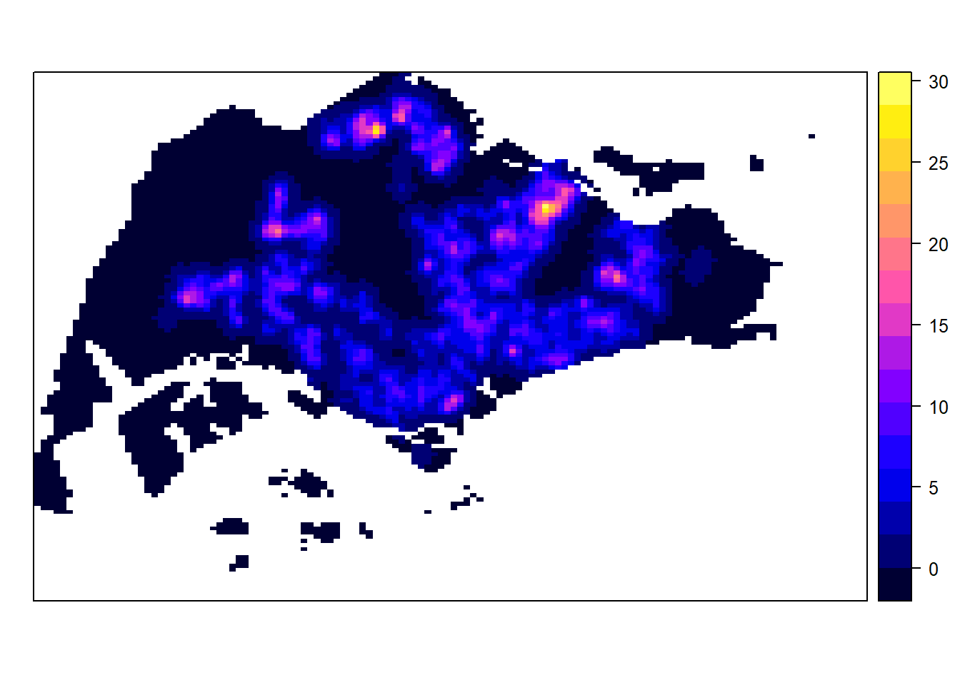
5.3.1 Converting gridded output into raster
kde_childcareSG_bw_raster <- raster(gridded_kde_childcareSG_bw)
kde_childcareSG_bw_raster
class : RasterLayer
dimensions : 128, 128, 16384 (nrow, ncol, ncell)
resolution : 0.4170614, 0.2647348 (x, y)
extent : 2.663926, 56.04779, 16.35798, 50.24403 (xmin, xmax, ymin, ymax)
crs : NA
source : memory
names : v
values : -8.476185e-15, 28.51831 (min, max)5.3.2 Assigning projection systems
projection(kde_childcareSG_bw_raster) <- CRS('+init=EPSG:3414')
kde_childcareSG_bw_raster
class : RasterLayer
dimensions : 128, 128, 16384 (nrow, ncol, ncell)
resolution : 0.4170614, 0.2647348 (x, y)
extent : 2.663926, 56.04779, 16.35798, 50.24403 (xmin, xmax, ymin, ymax)
crs : +init=EPSG:3414
source : memory
names : v
values : -8.476185e-15, 28.51831 (min, max)5.4 Visualizing the output in tmap
tm_shape(kde_childcareSG_bw_raster) +
  tm_raster("v") +
  tm_layout(legend.position = c("right", "bottom"),
            frame = FALSE)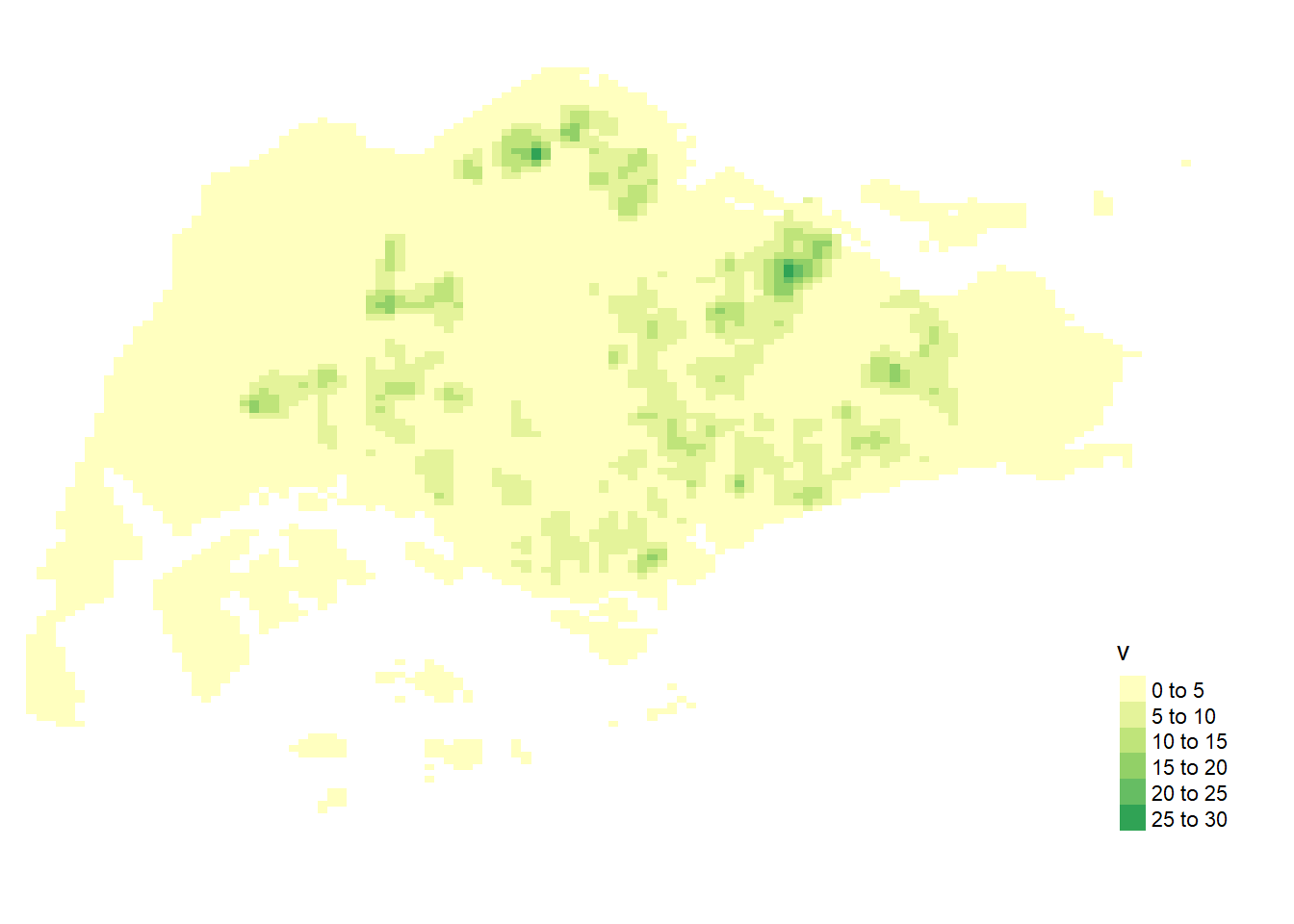
5.5 Comparing Spatial Point Patterns using KDE
5.5.1 Extracting study area
pg = mpsz[mpsz@data$PLN_AREA_N == "PUNGGOL",]
tm = mpsz[mpsz@data$PLN_AREA_N == "TAMPINES",]
ck = mpsz[mpsz@data$PLN_AREA_N == "CHOA CHU KANG",]
jw = mpsz[mpsz@data$PLN_AREA_N == "JURONG WEST",]par(mfrow=c(2,2))
plot(pg, main = "Punggol")
plot(tm, main = "Tampines")
plot(ck, main = "Choa Chu Kang")
plot(jw, main = "Jurong West")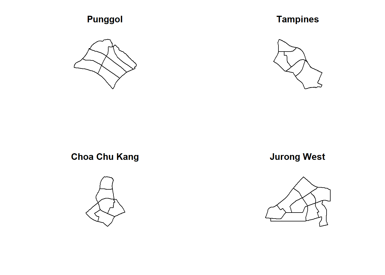
5.5.2 Converting the spatial point data frame into generic sp format
pg_sp = as(pg, "SpatialPolygons")
tm_sp = as(tm, "SpatialPolygons")
ck_sp = as(ck, "SpatialPolygons")
jw_sp = as(jw, "SpatialPolygons")
5.5.3 Creating owin object
pg_owin = as(pg_sp, "owin")
tm_owin = as(tm_sp, "owin")
ck_owin = as(ck_sp, "owin")
jw_owin = as(jw_sp, "owin")
5.5.4 Combining childcare points and the study area
childcare_pg_ppp = childcare_ppp_jit[pg_owin]
childcare_tm_ppp = childcare_ppp_jit[tm_owin]
childcare_ck_ppp = childcare_ppp_jit[ck_owin]
childcare_jw_ppp = childcare_ppp_jit[jw_owin]
childcare_pg_ppp.km = rescale(childcare_pg_ppp, 1000, "km")
childcare_tm_ppp.km = rescale(childcare_tm_ppp, 1000, "km")
childcare_ck_ppp.km = rescale(childcare_ck_ppp, 1000, "km")
childcare_jw_ppp.km = rescale(childcare_jw_ppp, 1000, "km")par(mfrow=c(2,2))
plot(childcare_pg_ppp.km, main="Punggol")
plot(childcare_tm_ppp.km, main="Tampines")
plot(childcare_ck_ppp.km, main="Choa Chu Kang")
plot(childcare_jw_ppp.km, main="Jurong West")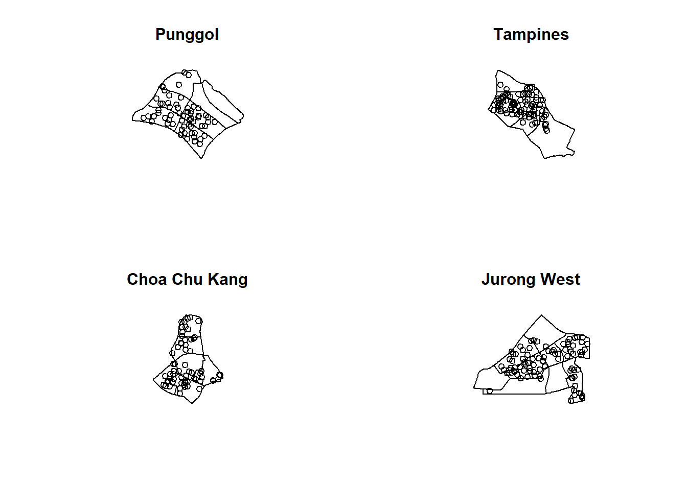
5.5.5 Computing KDE
par(mfrow=c(2,2))
plot(density(childcare_pg_ppp.km,
             sigma=bw.diggle,
             edge=TRUE,
             kernel="gaussian"),
     main="Punggol")
plot(density(childcare_tm_ppp.km,
             sigma=bw.diggle,
             edge=TRUE,
             kernel="gaussian"),
     main="Tempines")
plot(density(childcare_ck_ppp.km,
             sigma=bw.diggle,
             edge=TRUE,
             kernel="gaussian"),
     main="Choa Chu Kang")
plot(density(childcare_jw_ppp.km,
             sigma=bw.diggle,
             edge=TRUE,
             kernel="gaussian"),
     main="JUrong West")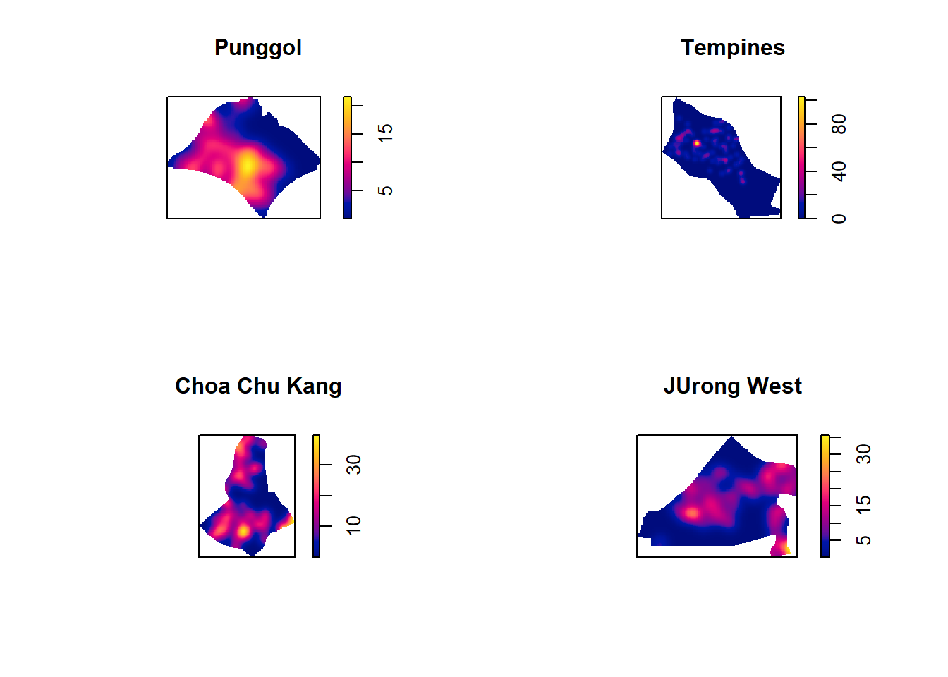
5.5.6 Computing fixed bandwidth KDE
par(mfrow=c(2,2))
plot(density(childcare_ck_ppp.km,
             sigma=0.25,
             edge=TRUE,
             kernel="gaussian"),
     main="Chou Chu Kang")
plot(density(childcare_jw_ppp.km,
             sigma=0.25,
             edge=TRUE,
             kernel="gaussian"),
     main="JUrong West")
plot(density(childcare_pg_ppp.km,
             sigma=0.25,
             edge=TRUE,
             kernel="gaussian"),
     main="Punggol")
plot(density(childcare_tm_ppp.km,
             sigma=0.25,
             edge=TRUE,
             kernel="gaussian"),
     main="Tampines")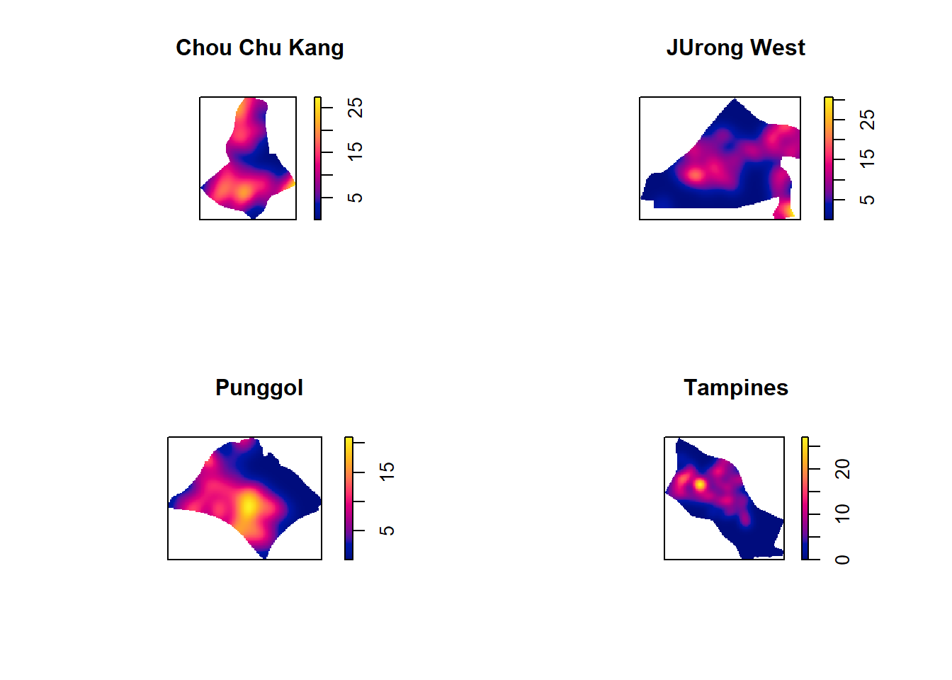
6 Nearest Neighbor Analysis
6.1 Testing spatial point patterns using Clark and Evans Test
clarkevans.test(childcareSG_ppp,
                correction="none",
                clipregion="sg_owin",
                alternative=c("clustered"),
                nsim=99)
    Clark-Evans test
    No edge correction
    Monte Carlo test based on 99 simulations of CSR with fixed n

data:  childcareSG_ppp
R = 0.54756, p-value = 0.01
alternative hypothesis: clustered (R < 1)
6.2 Clark and Evans Test: Choa Chu Kang planning area
clarkevans.test(childcare_ck_ppp,
                correction="none",
                clipregion=NULL,
                alternative=c("two.sided"),
                nsim=999)
    Clark-Evans test
    No edge correction
    Monte Carlo test based on 999 simulations of CSR with fixed n

data:  childcare_ck_ppp
R = 0.93607, p-value = 0.078
alternative hypothesis: two-sided
6.3 Clark and Evans Test: Tampines planning area
clarkevans.test(childcare_tm_ppp,
                correction="none",
                clipregion=NULL,
                alternative=c("two.sided"),
                nsim=999)
    Clark-Evans test
    No edge correction
    Monte Carlo test based on 999 simulations of CSR with fixed n

data:  childcare_tm_ppp
R = 0.77315, p-value = 0.002
alternative hypothesis: two-sided